 |
| Cardon Cactus, arid rough landscape, clear water and plenty of sun are icons of Baja California. Photo was taken near Playa Santispac on Bahia Concepcion in the Sea of Cortez |
Curtis and Sheri flew down to Cabo del San Jose and met up with Dawn and Bob for a tour around Baja California Sur, Mexico.
 |
| Baja California is split into two states. This map is of the southern state of Baja California Sur. |
We all met up on the East Cape at a house on the ocean at Cabo Pulmo. Cabo Pulmo is a National Marine Park. Unfortunately the wind was blowing hard from the north for a few days.
 |
| Villa del Mar on the beach at Cabo Pulmo on the east cape of Baja Sur. The wind blew strong continuously from the north for the first few days of our trip. |
 |
| Don and Bob looking over the ocean at Villa del Mar. |
 |
| Dawn and Bob at sunrise at Villa del Mar. |
 |
| Sheri practicing her uke at Villa del Mar. |
To get away from the coast wind we drove over to Santiago and to the village of Agua Caliente. At roads end we walked from a failed irrigation dam up a granite desert canyon.
 |
| Near the oasis at Agua Caliente. |
 |
| The small river at Agua Caliente is a clear flowing stream set in a rugged granite canyon in the the Sierra la Laguna mountains. The Sierra peaks top out at about 7000 feet. Not what we expected in Baja. |
 |
| Solid granite rock lines the canyon of Agua Caliente. |
 |
| Warming up and drying off on the rocks after a swim. |
After a a couple of swims and a wandering walk (Los Perdidos Baja Death March) though the desert we stopped by the quiet town of La Ribera for a bit to eat.
 |
| No name burrito place in La Ribera north of Cabo Pulmo. Busiest place in the town. |
We drove over to Los Frailes with the thought that the headland would block the north wind. We weren't the only ones. Some local teens were at the beach with florescent green and red inner tubes. At the distance, we saw the green inner tube caught in the wind, flipping over and over across the sea. We could see splashing water were a swimmer was in pursuit but he gave up. The inner tube steadily blew out to sea and was lost behind some anchored fishing boats. Not so long after that a fisherman climbed down off a big fishing boat in to a ponga. He started the motor and zipped off. A few minutes later he appeared from behind the boat racing towards the shore with the green inner tube hooked on his arm. He arrived at the beach with the prize to no avail; the teens had gotten cold and left the beach.
 |
| Palapas on the beach at Los Frailes. Los Frailes area is formed by a granite headland that sticks into the Sea of Cortez and forms a long granite sand beach. |
 |
| Granite rocks at Los Frailes are washed with cool clear water from the Sea of Cortez. The area was good for snorkeling with a few clumps of coral and huge schools of fish. |
 |
| Los Frailes |
 |
| Sheri at Los Frailes in her wet suit she brought for swimming in the cool water in Baja. |
 |
| Sheri, Bob and Dawn staying close to the rocks to get out of the strong wind. |
 |
| Sheri and Curtis at Los Frailes. |
 |
| Photo of a poster with schools something like we saw. |
 |
| Raptor on the look out at sunset at Cabo Pulmo. |
 |
| Caves used by aboriginal people for burial at Cabo Pulmo. |
 |
| Cardon Cactus |
 |
| Cardon Cactus at Cabo Pulmo |
From Cabo Pulmo we motored up to La Paz, the capital of Baja California Sur. Sheri booked a room at One Hotel. We had heard it was Carnival festival in La Paz and wanted to see what was going on.
 |
| One Hotel in La Paz. Tallest building in town. Brand new and completely white and sterile, but only a few blocks to the Malecon, the haborside esplanade. |
 |
| Taco tent restaurant at the Carnival Festival in La Paz. The whole Malecon was converted to a multi-stage fiesta. |
 |
| Curtis bought Dawn a tropical drink to put her in the party mood Carnival. Chatty bartenders were super happy to make our drinks. |
 |
| Kitchen store at the carnival. Sheri bought the smallest cheese grater on earth. |
 |
| Sheri with her Red Snapper al lena at Bismark Restaurant on the Malecon in La Paz. |
 |
| Bizarre arcade booth. Shoot the targets and activate macabre miniature vignettes of famous Mexican bands. Shoot all the targets and activate a child size mannequin with a hockey mask. It lights up and starts chopping with an axe. Then a stream of liquid squirts out of the mannequin's crouch and the whole thing rotates back and forth. |
 |
| Headliners for the night we were at Carnival - "Los Angeles Azules"- 17 piece band. |
 |
| Sunset at Tecolote Beach north of La Paz. |
 |
| Tecolote Beach Sunset |
 |
| Curtis at Playa Tecolote |
 |
| Playa Tecolote at sunrise. |
 |
| Coffee and breakfast Tecolote Beach |
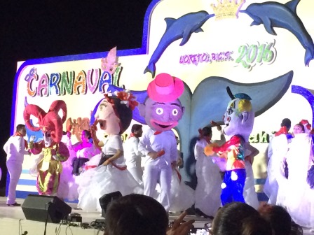
We pressed on north from La Paz. There's not much of interest for a few hours from La Paz until Highway 1 drops back down to the Sea of Cortez south of Loreto. As it turns out we arrived at Loreto are dark while their dance troops and floats were being presented in Loreto's Carnaval festival. The streets were jammed up with traffic so we went on foot to find the Junipero Hotel. Loreto is a nice mellow town in a beautiful setting on the Sea of Cortez backed by the Gigante Mounains.
 |
| Carnival festival at Loreto |
 |
| Pedestrianized street in Loreto |
 |
| Sunset over the Sea of Cortez at Loreto. |
 |
| Las Gigantes from Loreto. |
 |
| The first annual Blue Whale Festival in Loreto. |
 |
| Hotel Plaza Loreto where we stayed. |
 |
| A palapa and glassed in sunroom built around a an RV trailer. |
 |
| Curtis in front of an old house near the square in San Antonio. |
 |
| Add caption |
 |
| Cardon Cactus in the desert north of Loreto. |
 |
| A tall boy on the side of Highway 1. |
We drove north and arrived at the town of San Ignacio. From there we drove 70 kilometers out to the Laguna San Ignacio. The Laguna is a shallow bay were Grey Whales overwinter, breed and give birth. The shore is desolate, low laying and dead flat.
 |
| La Fridera is a former fishing camp where Antonio's whale watching tours operates on Laguna San Ignacio. |
 |
| Laguna San Ignacio from the window of our flight home. |
 |
| Shells on the beach at Laguna San Ignacio. |
 |
| Sunset over Laguna San Ignacio |
 |
| Sunset over Laguna San Ignacio |
 |
| Drive from Laguna San Ignacio back to San Ignacio town in our Jeep Patriot. |
 |
| Salt flats near Laguna San Ignacio with Santa Clara mountains in the distance. |
 |
| Sunset over the hotel La Huerta in San Ignacio. |
 |
| Ruins of the silver smelter next to the highway at Santa Rosalia. |
After Whale watching we moseyed down south to Bahia Concepcion and camped out at Playa Santispac. We camped at the edge of the beach since the middle part was full of RV's.
 |
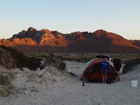
| Camp at Playa Santispac |
 |
| Sheri at our camp at Playa Santispac. |
 |
| Bahia de Concepcion at Playa Santispac. |
 |
| Sheri hiking around the headland at Playa Santispac. |
 |
| Hiking around the headland at Playa Santispac. |
 |
| Eroded overhang along the Sea of Cortez, Bahia Concepcion. |
 |
| Early morning SUP. |
 |
| Sheri playing her uke. |
 |
| Our camp at Playa Santispac. |
 |
| Sunrise |
 |
| Early morning on the Sea of Cortez. |
 |
| Sunrise. |
 |
| Sunrise |
A local guy stopped by our tent and offered up a double kayak for rent for 400 pesos. We got him down to 200 pesos. We paddled out to a small Island with a perfect sheltered little beach at the south tip. We shared Sheri's wet suit for some snorkeling around the island.
 |
| Beach at Pithaya Island |
 |
| Beach at Pithaya Island |
 |
| Beach at Pithaya Island |
 |
| Requeson Beach and Island in the Bahia Concepcion |
 |
| Beautiful cactus and coast line at Bahia Concepcion |
We decided to drive to Agua Verde, a fishing village at the end of a gravel road. The road started out good but step by step it became rough and very steep. The road clung to the edge of the mountain on the decent to the beach.
 |
| Mountains at the start of the gravel road to Agua Verde. |
 |
| Looking along the Sea of Cortez towards Agua Verde. |
 |
| Our camp at Agua Verde. |
 |
| Hiking north from the beach at Agua Verde. |
 |
| Sheri at Agua Verde |
 |
| Fishermen landing a ponga at sunset. |
 |
| Fisherman after he landed his boat at Agua Verde. |
 |
| Los pescadores at Agua Verde. Bought a fish from these guys for 100 pesos. |
 |
| Sheri cooking Red Snapper filet at Agua Verde. |
 |
| Sunrise at Agua Verde |
 |
| Sunrise at Agua Verde |
After departing Agua Verde we stopped by Coffee Star in Ciudad Constitution for a couple of lattes and a picnic lunch. It was St Valentines Day so Curtis booked a romantic room at Hotel California in Todos Santos. The hotel is a character filled place where pretty much everyone who comes to Todos Santos stops by for a look.
 |
| Hotel California in Todos Santos. |
 |
| Gate to separate hotel guests from random visitors. |
 |
| Inner lobby of Hotel California |
 |
| Terrace off our room at Todos Santos |
 |
| Happy Valentines Day! |
 |
| Inner pool and garden area at Hotel California. |
We headed south, with a stop at Baja Beans for cappuccinos, and arrived at our hotel in Cabo San Lucas, Fairfield Inn. We moseyed around town, the marina, Cabo Wabo, and dinner at the beach restaurant "The Office".
 |
| Dolphin Rock at Lovers Beach, Land's End, Cabo San Lucas. |
 |
| Many a ponga makes the trip to Lovers beach from the marina in Cabo San Lucas. |
 |
| Folks were landing at the beach in a good swell. It made for good people watching as people hopped, jumped, fell and rolled on to the beach. |
 |
| To leave Lovers Beach people piled on to get onto pongas in the swell. |
 |
| Lovers Beach |
 |
| Sheri at Lovers Beach |
 |
| Divorce Beach on the Pacific side of the cape. |
 |
| Beautiful smooth granite on the Cabo San Lucas. |
 |
| Pacific surf pounds the rocks on the west side of the cape. |
 |
| Granite canyon along the cape. |
 |
| The beach at Solmar. Granite rocks and soft clean granite sand. |
 |
| On the esplanade at the marina in Cabo San Lucas. |
 |
| Boats at the marina in Cabo San Lucas |
 |
| Marina at Cabo San Lucas |
 |
| Sheri on Playa Mediano, the main beach at Cabo San Lucas. |
 |
| Beach hawkers on Medano Beach |
 |
| Center of the action at Medano Beach. |
 |
| Busy beach front on Medano Beach. |
 |
| Sheri's favorite restaurant in Cabo San Lucas "The Office". |
 |
| Sheri at her favorite restaurant "The Office". |
 |
| Santa Maria beach. |
 |
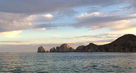
| Finisterra - Land's End, Cabo San Lucas. |
 |
| Aerial view from our departure flight of the harbor at San Jose del Cabo |
 |
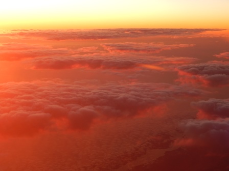
| As we were flying north above the clouds the sun set and illuminated the under side of the clouds. |
 |
| Sunset from our flight home. |
 |
| Adios Baja |


No comments:
Post a Comment